|
Dolly Sods is located within the Monongahela National Forest in East-Central West
Virginia. Our autumn backpacking trip encompassed what is known as North Dolly Sods
and the Dolly Sods Wilderness. There is a plethora of general information on the
internet regarding this unique Dolly Sods area, so I will not go into great detail
about Dolly Sods aside from 1) saying that Dolly Sods is one of the most unique hiking
endeavors that one may ever experience East of the Mississippi and, 2) providing you
the following link to a short term paper that I wrote on the ecological history of
Dolly Sods: Dolly Sods Term Paper.
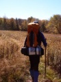
The roughly 19 miles that Brad, Chris, Jeremy, Joel and myself hiked, if I may say so,
were near perfect for capturing a large picture of what Dolly Sods is all about.
In addition, it was also one of the most
diverse 19 miles we've covered. Beginning at the famed Bear Rocks Preserve, we hiked
generally south-southwest around Blackbird Knob, down the Left Fork, across Breathed
Mountain, up and around Lion's Head, down to Red Creek and out via "the Cliffs" and the
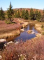
Rohrbaugh Plains Trail. This route comprised soggy bogs, vast views, dense forests,
extreme heights and trails (along with non-trails) that led to the most contended
meadows that we've ever set foot in. I could easily spend as many days talking about
our experience as we did backpacking.
With that said, I'm simply going to provide a brief overview in pictures and touch on
some highlights of the trip below. Frankly, the best way for you to understand what
Dolly Sods is truly like is for you to visit yourself. Assuming that you're prepared,
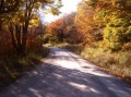
you won't regret it. And even if you're not prepared - there are family-friendly ways
to access the perimeter of Dolly Sods via Forest Roads 19 and 75.


- - - - - - - - - - - - - - - - - - - - - - - -
- - - - - - - - - - - - - - - - - - - - - - - - - - - - - - -
For a complete line of backpacking gear -- check out EverestGear.com!

- - - - - - - - - - - - - - - - - - - - - - - -
- - - - - - - - - - - - - - - - - - - - - - - - - - - - - - -
Black Goat
Within 200 yards of our onset, Chris had already nicknamed me the "Black Goat."
In an email he explained:
"The Black Goat is my trail name for Robert, 'cause he was dressed in black from
head to ankle as we started the trip, exploring the Bear Rocks rock formation at
the trail head. He reminded me of one of those high-altitude mountain goats you
see pictures of, scampering and bounding over impossible rock grades in the Himalayas."
The name stuck the whole trip, and if you
heard, "ask the Goat," you easily understood what was meant. I like the name.
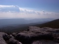
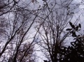
Wind
The wind at Bear Rocks (or any of the high, exposed points for that matter) was near
unbelievable. The wind was fierce, and protection from it was a must.
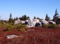
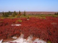
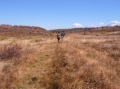
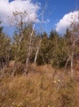
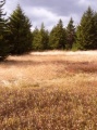
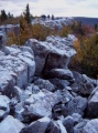
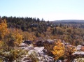
North Sods
North Dolly Sods was beautiful; very open grassland with grand views!
Bush Whacking
As I eluded to in the opening remarks, there was a bit of intentional bush whacking involved in the
weekend. Neither of the Birdsall boys were too familiar with the idea. But once we
set foot BACK onto the trail, Joel said, "I guess he *does* know what he's doing."
(I'm sure they would want to remind me of the near full-circle that I made on Day 2
before I decided to pull out the compass. At the least, though, it only took me
about 10 minutes to realize that something wasn't right.)
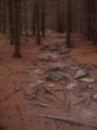
It got pretty hairy bush whacking along the Left Fork - just north of the Breathed
Mt. trail, on top of the western slope of the run where the bank is high and steep,
close to where the small run that trickles down from the Beaver ponds intersects the
Left Fork. At a couple points, we had to squat down, tuck our heads and barrel
forward through the tight groves of young Hemlock - hoping to come out on the other
side intact.
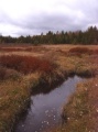
Even though there is not an official trail along the Left Fork, it is hikable, and
there are some nice camping spots, especially along the northern portion. The
southern portion of the fork is likely not quite as "hairy" if you stay along the
creek itself, rather than up on the ridge. It is gorgeous though! The next outing,
I'm hoping to hike up the Red Creek Trail to the bend that takes you to that little
run that comes down from the Beaver Ponds, and then hike up it. It's a very unique
run, and will be well worth any scratches or tears.
Bad Maps / Good Maps
The trail markings on the USGS Topographical maps are, in certain places, inaccurate
- especially in the areas of 1) Red Creek Trail and Blackbird Knob Trail junction, 2)
Breathed Mt. Trail (easterly portion), and 3) Fisher Spring Run Trail (westerly
portion). When at the junction of Blackbird Knob Trail and Red Creek, we ran into
a large group of college students from Wittenberg University. At that time I was
still under the impression that the USGS Topos were accurate - even though I had
received a new version of the map prepared by the US Army Corps of Engineers from the
ranger's office. I did not do a simple comparison of the maps when planning out the
route. Thus, when the Wittenberg students asked where they were and how to get to
the "the Forks," I suggested a route that, to this day, I'm not sure existed.
Regardless, the following day we ran into them again at the large falls on the Big
Stonecoal Trail. They had found the falls they were looking for, had been to Lion's
Head, and were thoroughly enjoying themselves. I apologized for the poor directions
priorly given, and informed them that the USGS Topo was inaccurate. (I had come to
this realization when we, ourselves, just after our initial rendez-vous with the
students, finally found the Red Creek Trail and Blackbird Knob Trail on top of
Blackbird Knob - not at Red Creek itself.)
So, which maps should you use? Well, the official answer is: you'll have to do the
research and decide yourself. But, I would suggest starting your research with the
following maps:
WV Highlands -- Dolly Sods Area 24K Maps
John Trudy -- Our Dolly Sods Mapping Project
Whitegrass Maps
U.S. Army Corps of Engineers -- Trail Map
I doubt you'll find anything more accurate. But you decide.
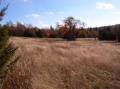
"Meadow Junkies"
Chris appropriately dubbed our group as the "meadow junkies." We thrived on tucking
our heads and burrowing into a Spruce grove just to burst out on the other side into
a newfound, profoundly inspiring meadow. The plateau's meadows are one of the
primary reasons I enjoy Dolly Sods so much. So much so, that when I thought about
my answer to the question, "If you could only be in one single spot in Dolly Sods,
where would it be," after a brief pondering, soon came to the conclusion that the
one spot would be an unnamed meadow along the Breathed Mt Trail.
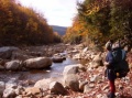
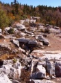
Run Walking
Run walking: this is not a oxymoron. The "run" is Big Stonecoal. If hiking south
on the Big Stonecoal Trail, just south of the junction of the Dunkenbarger Trail,
the trail crosses to the eastern bank of the Big Stonecoal Run. At this crossing,
it is very feasible (and a lot of fun) to hike down the run itself rather then
continuing on the trail. If the water level is normal, the boulders are large enough
and in great enough number to stay completely dry (if you're skilled, of course).
If deciding to go boulder hopping, you can go as far as the big falls. (It may be
possible to go beyond the falls, but the trail, at the point of the falls, begins
to increase in elevation, thus making it inefficient to continue down the run if
you're heading up to Lion's Head.)
Just a note: there are points within the Left Fork to boulder hop as well.
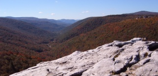
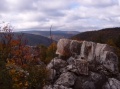
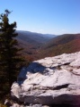
Lion's Head
This may be hard to believe, but of all the prior backpacking trips in Dolly Sods,
this is the first time that we actually went up to Lion's Head. It is, in my
opinion, by far the best "mountain view" in the wilderness area. It is a grand,
sweeping, awe inspiring view. Don't miss it! I will say no more, except - be
careful.
The Keys?
Mid afternoon on Day 1, Brad attentively said, "I left my keys in Chris' car."
Hmm... Well, at least he wasn't referring to his van. So, should a couple of us
hike back to the car to get his van keys, or should we chance hitch hiking
at the end of the trail on Day 3? We opted for hitch hiking.
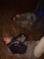
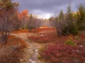
Overall
Overall, the colors were dramatic, the scenery - magnificent, moon/star gazing -
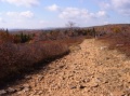
calming, and the trail - at times - "rocky and wet."
|